
Forsinain Forest Wind Farm
Low Carbon is proposing a new wind farm, to be known as Forsinain Forest Wind Farm, located on land adjacent to the A897, 3km north of Forsinard and 16km south of Melvich in Sutherland in The Highland Council area.
The Proposed Development will generate 86.4 Megawatts (MW) of clean, green renewable power.
Welcome to
Forsinain Forest Wind Farm

Craig Cunningham
Senior Project Development Manager
Low Carbon is proposing a new wind farm, to be known as Forsinain Forest Wind Farm, located on land adjacent to the A897, 3km north of Forsinard and 16km south of Melvich in Sutherland in The Highland Council area. The Proposed Development is sited outwith all nationally designated land and The Flow Country UNESCO World Heritage site.
The Proposed Development will generate 86.4 Megawatts (MW) of clean, green renewable power.
A Scoping submission to the Scottish Government’s Energy Consents Unit seeking consultees opinions on the scope of environmental assessments was made in September 2023.
A Section 36 application was subsequently made to the Scottish Government’s Energy Consents Unit in August 2026.
The Section 36 application can be viewed here: Scottish Government - Energy Consents Unit - Application Details
Application Documents
In August 2026, Low Carbon submitted a Section 36 Application and Environmental Impact Assessment Report to the Scottish Government’s Energy Consents Unit (ECU) for Forsinain Forest Wind Farm. The Proposed Development consists of up to 12 turbines with a maximum tip height of 219m and associated infrastructure. The full suite of application documents can be viewed using the links below.
If you would like a download link for the full application emailed directly to you, please contact: info@forsinainforestwindfarm.co.uk.
All documents can also be viewed and downloaded via the SG Website
Public Notice
Vol 01 - Non Technical Summary
Vol 02 - Environmental Impact Assessment Chapters
- Vol 2 Cover & Contents Page
- Chapter 1 Introduction
- Chapter 2 Project Description
- Chapter 3 Design Evolution and Alternatives
- Chapter 4 Landscape and Visual
- Chapter 5 Ecology
- Chapter 6 Ornithology
- Chapter 7 Geology Peat Hydrology and Hydrogeology
- Chapter 8 Noise
- Chapter 9 Cultural Heritage
- Chapter 10 Access Traffic and Transport
- Chapter 11 Schedule of Mitigation
- Chapter 12 Summary of Effects
Vol 3a - Figures
- Vol 3a Cover Contents Page
- Figure 1.1 Site Location
- Figure 1.2 Application Boundary
- Figure 2.1 Site Access
- Figure 2.2a Site Layout with All Access Points Ordnance Survey Mapping
- Figure 2.2b-c Site Layout Using Access Point 2 Options A & B Ordnance Survey Mapping
- Figure 2.3a Site Layout with All Access Points Aerial Imagery
- Figure 2.3b-c Site Layout Using Access Point 2 Options A & B Aerial Imagery
- Figure 2.4a Typical Turbine Elevation 219m Tip Height
- Figure 2.4b Typical Turbine Elevation 206m Tip Height
- Figure 2.5 Typical Turbine Foundation Detail
- Figure 2.6 Typical Track Details
- Figure 2.7 V162 Typical Crane Hardstanding
- Figure 2.8 Typical 33kilovolt Six Circuit Trench Detail
- Figure 2.9 Typical Onsite Substation Layout
- Figure 2.10 Typical Onsite Substation Elevations
- Figure 2.11 Typical Construction Compound
- Figure 2.12 Typical Watercourse Crossings Details
- Figure 2.13 Typical River Halladale Bridge Crossing
- Figure 2.14 Typical 100m Anemometer Mast
- Figure 3.1 National and International Environmental Designations
- Figure 3.2a-c On Site Constraints
- Figure 3.2d-e On Site Constraints
- Figure 3.3 Wind Turbine Layout Evolution
- Figure 3.4 Infrastructure Design Evolution
- Figure 3.5a-c Comparative Wirelines Viewpoint 1-3
- Figure 3.5d Comparative Wirelines Viewpoint 4
- Figure 3.5e-g Comparative Wirelines Viewpoint 5-7
- Figure 3.5h-j Comparative Wirelines Viewpoint 8-10
- Figure 3.5k Comparative Wirelines Viewpoint 11
- Figure 3.5l Comparative Wirelines Viewpoint 12
- Figure 3.5m Comparative Wirelines Viewpoint 13
- Figure 3.5n-o Comparative Wirelines Viewpoint 14-15
- Figure 3.5p-r Comparative Wirelines Viewpoint 16-18
- Figure 3.5s Comparative Wirelines Viewpoint 19
- Figure 3.5t-u Comparative Wirelines Viewpoint 20-21
- Figure 3.5v Comparative Wirelines Viewpoint 22
- Figure 3.6a-c Comparative Wirelines Residential Viewpoint 1-3
- Figure 3.6d-e Comparative Wirelines Residential Viewpoint 4-5
- Figure 3.6f-h Comparative Wirelines Residential Viewpoint 6-8
- Figure 4.1 Site Location and Study Area
- Figure 4.2 Landform
- Figure 4.3a Landscape Character (45km Radius)
- Figure 4.3b Landscape Character (20km Radius)
- Figure 4.4a Landscape Designations (45km Radius)
- Figure 4.4b Landscape Designations (20km Radius)
- Figure 4.5a Wild Land Areas (45km Radius)
- Figure 4.5b Wild Land Areas (20km Radius)
- Figure 4.6a Principal Visual Receptors (45km Radius)
- Figure 4.6b Principal Visual Receptors (20km Radius)
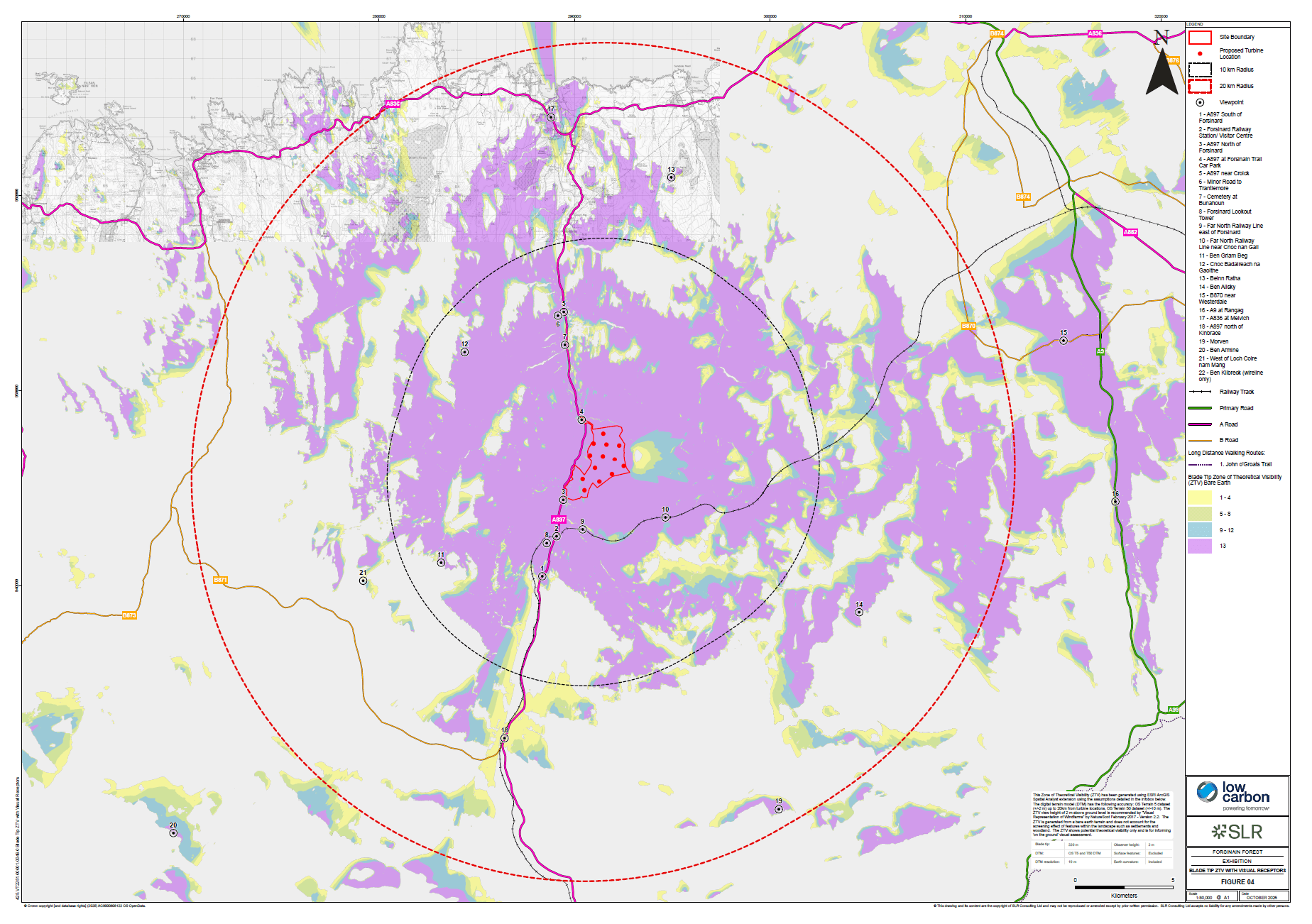
- Figure 4.7a Blade Tip Zone of Theoretical Visibility with Viewpoints (45km Radius)
- Figure 4.7b Blade Tip Zone of Theoretical Visibility with Viewpoints (20km Radius)
- Figure 4.7c Blade Tip Zone of Theoretical Visibility with Viewpoints (45km Radius)
- Figure 4.7d Blade Tip Zone of Theoretical Visibility with Viewpoints (20km Radius)
- Figure 4.8a Hub Height Zone of Theoretical Visibility with Viewpoints (45km Radius)
- Figure 4.8b Hub Height Zone of Theoretical Visibility with Viewpoints (20km Radius)
- Figure 4.8c Hub Height Zone of Theoretical Visibility with Viewpoints (45km Radius)
- Figure 4.8d Hub Height Zone of Theoretical Visibility with Viewpoints (20km Radius)
- Figure 4.9a Baseline Light Pollution
- Figure 4.9b Turbine Lighting Zone of Theoretical Visibility (20km Radius)
- Figure 4.9c Lighting Intensity Zone of Theoretical Visibility (20km Radius)
- Figure 4.10a Landscape Character with Blade Tip Zone of Theoretical Visibility (45km Radius)
- Figure 4.10b Landscape Character with Blade Tip Zone of Theoretical Visibility (20km Radius)
- Figure 4.11a Landscape Designations with Blade Tip Zone of Theoretical Visibility (45km Radius)
- Figure 4.11b Landscape Designations with Blade Tip Zone of Theoretical Visibility (20km Radius)
- Figure 4.12a Wild Land Areas with Blade Tip Zone of Theoretical Visibility (45km Radius)
- Figure 4.12b Wild Land Areas with Blade Tip Zone of Theoretical Visibility (20km Radius)
- Figure 4.13a Principal Visual Receptors with Blade Tip Zone of Theoretical Visibility (45km Radius)
- Figure 4.13b Principal Visual Receptors with Blade Tip Zone of Theoretical Visibility (20km Radius)
- Figure 4.14a Cumulative Wind Farms (60km Radius)
- Figure 4.14b Cumulative Wind Farms (45km Radius)
- Figure 4.15a Cumulative Zone of Theoretical Visibility Achairn, Bilbster, Camster I and II, Wathergar 1 and 2
- Figure 4.15aa Cumulative Zone of Theoretical Visibility Strathy North
- Figure 4.15ab Cumulative Zone of Theoretical Visibility Strathy South
- Figure 4.15ac Cumulative Zone of Theoretical Visibility Strathy Wood
- Figure 4.15ad Cumulative Zone of Theoretical Visibility Stroupster
- Figure 4.15ae Cumulative Zone of Theoretical Visibility Swarclett
- Figure 4.15af Cumulative Zone of Theoretical Visibility Tormsdale
- Figure 4.15ag Cumulative Zone of Theoretical Visibility West Clyth Repowering
- Figure 4.15b Cumulative Zone of Theoretical Visibility Achlachan, Bad a Cheo, Causeymire, Halsary and Tacher A, B and C
- Figure 4.15c Cumulative Zone of Theoretical Visibility Achlachan 2 Redesign
- Figure 4.15d Cumulative Zone of Theoretical Visibility Baillie Hill
- Figure 4.15e Cumulative Zone of Theoretical Visibility Bettyhill
- Figure 4.15f Cumulative Zone of Theoretical Visibility Bettyhill Phase 2
- Figure 4.15g Cumulative Zone of Theoretical Visibility Burn Of Whilk
- Figure 4.15h Cumulative Zone of Theoretical Visibility Buolfruich
- Figure 4.15i Cumulative Zone of Theoretical Visibility Cairnmore Hill Resubmission
- Figure 4.15j Cumulative Zone of Theoretical Visibility Chleansaid
- Figure 4.15k Cumulative Zone of Theoretical Visibility Cogle Moss
- Figure 4.15l Cumulative Zone of Theoretical Visibility Creag Riabhach and Extension
- Figure 4.15m Cumulative Zone of Theoretical Visibility Forss I, II and III
- Figure 4.15n Cumulative Zone of Theoretical Visibility Golticlay Variation
- Figure 4.15o Cumulative Zone of Theoretical Visibility Golticlay Extension
- Figure 4.15p Cumulative Zone of Theoretical Visibility Gordonbush and Extension
- Figure 4.15q Cumulative Zone of Theoretical Visibility Hill of Lychrobbie Variation
- Figure 4.15r Cumulative Zone of Theoretical Visibility Hollandmey
- Figure 4.15s Cumulative Zone of Theoretical Visibility Kilbraur and Extension
- Figure 4.15t Cumulative Zone of Theoretical Visibility Limekiln Variation and Extension
- Figure 4.15u Cumulative Zone of Theoretical Visibility Lochend
- Figure 4.15v Cumulative Zone of Theoretical Visibility Lochend Extension
- Figure 4.15w Cumulative Zone of Theoretical Visibility Melvich
- Figure 4.15x Cumulative Zone of Theoretical Visibility Pentland Offshore
- Figure 4.15y Cumulative Zone of Theoretical Visibility Slickly
- Figure 4.15z Cumulative Zone of Theoretical Visibility Strath Tirry
- Figure 5.1a Statutory Designated Sites Within 10 km
- Figure 5.1b Non-statutory Designated Sites within 2 km
- Figure 5.2a-d Phase 1 Habitat Survey Results
- Figure 5.2e-h Phase 1 Habitat Survey Results
- Figure 5.3a-c National Vegetation Classification Survey Results
- Figure 5.3d-f National Vegetation Classification Survey Results
- Figure 5.3g-h National Vegetation Classification Survey Results
- Figure 5.4a-c Areas of Potential Groundwater Dependent Terrestrial Ecosystems
- Figure 5.4d-h Areas of Potential Groundwater Dependent Terrestrial Ecosystems
- Figure 5.5a-d Protected Species Survey Results
- Figure 5.6a-b Protected Species Sightings
- Figure 5.7 Bat Activity Survey Detector Locations
- Figure 5.8a-d Bat Survey Potential Roosting Features
- Figure 5.8e-f Bat Survey Potential Roosting Features
- Figure 5.9a-d Electrofishing Survey Locations
- Figure 5.10 Obstacles to Fish Migration
- Figure 6.1 Site Context in relation to Natural Heritage Future Zones, Special Protection Areas and Ramsars
- Figure 6.2 Site Context in relation to Special Protection Areas, Ramsars and other Wind Farms
- Figure 6.3 Site Context in relation to Designated Sites and Wind Farm Developments
- Figure 6.4 Local Site Context in relation to Designated Sites and Wind Farm Developments
- Figure 6.5 Local Context of Site and RSPB Forsinard Flows Nature Reserve
- Figure 7.1 Hydrology Features
- Figure 7.2a-e Watercourses and Flooding
- Figure 7.3 Soils
- Figure 7.4 Superficial Geology
- Figure 7.5 Peatland Classification
- Figure 7.6 Peat Depth
- Figure 7.7 Peat Condition Assessment
- Figure 7.8 Bedrock Geology
- Figure 7.9 Aquifer Classification and Groundwater Vulnerability
- Figure 7.10a-h Areas of Potential Groundwater Dependent Terrestrial Ecosystems
- Figure 8.1 35 decibel and 25 decibel Development Operating in Isolation
- Figure 8.2 35 decibel and 25 decibel Development and Cumulative Developments Operating Simultaneously
- Figure 8.3 Noise Monitoring Positions
- Figure 9.1 Heritage Assets Within The Site
- Figure 9.2 Heritage Assets within the 1km Study Area
- Figure 9.3 Heritage Assets within the 5km and 10km Study Areas
- Figure 9.4 Heritage Assets and the Zone of Theoretical Visibility
- Figure 9.5 Peat Depths Across Site
- Figure 9.6 Extract from Roy's Military Survey
- Figure 9.7 Extract from Ordnance Survey Map, 1878
- Figure 9.8 Extract from Ordnance Survey Map, 1962-1966
- Figure 10.1 Study Area
- Figure 10.2 Traffic Count Locations
- Figure 10.3 Personal Injury Accident Locations
- Figure 10.4 Abnormal Indivisible Load Delivery Route
- Figure 10.5 Access Point 1 Swept Path Assessment
- Figure 10.6 Access Point 2 - Option A General Arrangement
- Figure 10.7 Access Point 2 - Option A Visibility Splay
- Figure 10.8 Access Point 2 - Option B General Arrangement
- Figure 10.9 Access Point 2 - Option B Visibility Splays
Vol 3b - NatureScot Visualisations (Viewpoint 1-10)
- Vol 3b Cover & Contents Page
- Figure 4.16a-h NatureScot Viewpoint 1 A987 South of Forsinard
- Figure 4.17a-e NatureScot Viewpoint 2 Forsinard Railway Station Visitor Centre
- Figure 4.18a-e NatureScot Viewpoint 3 A987 North of Forsinard
- Figure 4.19a-g NatureScot Viewpoint 4 A987 at Forsinain Trail Car Park
- Figure 4.20a-e NatureScot Viewpoint 5 A987 near Croick
- Figure 4.21a-e NatureScot Viewpoint 6 Minor Road to Trantlemore
- Figure 4.22a-g NatureScot Viewpoint 7 Cemetery of Bunahoun
- Figure 4.23a-f NatureScot Viewpoint 8 Forsinard Lookout Tower
- Figure 4.24a-f NatureScot Viewpoint 9 far North Railway Line east of Forsinard
- Figure 4.25a-f NatureScot Viewpoint 10 Far North Railway Line near Cnoc nan Gall
Vol 3c - NatureScot Visualisations (Viewpoint 11-22)
- Vol 3c Cover & Contents Page
- Figure 4.26a-h NatureScot Viewpoint 11 Ben Griam Beg
- Figure 4.27a-h NatureScot Viewpoint 12 Cnoc Badaireach no Gaoithe
- Figure 4.28a-h NatureScot Viewpoint 13 Beinn Ratha
- Figure 4.29a-j NatureScot Viewpoint 14 Ben Alisky
- Figure 4.30a-g NatureScot Viewpoint 15 B870 near Westerdale
- Figure 4.31a-g NatureScot Viewpoint 16 A9 at Rangag
- Figure 4.32a-f NatureScot Viewpoint 17 A836 at Melvich
- Figure 4.33a-e NatureScot Viewpoint 18 A897 north of Kinbrace
- Figure 4.34a-h NatureScot Viewpoint 19 Morven
- Figure 4.35a-h NatureScot Viewpoint 20 Ben Armine
- Figure 4.36a-e NatureScot Viewpoint 21 West of Loch Coire nam Mang
- Figure 4.37a-f NatureScot Viewpoint 22 Ben Klibreck
Vol 3d - The Highland Council Visualisations (Viewpoint 1-10)
- Vol 3d Cover & Contents Page
- Figure 4.38 The Highland Council Viewpoint 1 A897 South of Forsinard
- Figure 4.39 The Highland Council Viewpoint 2 Forsinard Railway Station Visitor Centre
- Figure 4.40 The Highland Council Viewpoint 3 A897 North of Forsinard
- Figure 4.41 The Highland Council Viewpoint 4 A897 at Forsinain Trail Car Park
- Figure 4.42 The Highland Council Viewpoint 5 A897 near Croick
- Figure 4.43 The Highland Council Viewpoint 6 Minor Road to Trantlemore
- Figure 4.44 The Highland Council Viewpoint 7 Cemetery at Bunahoun
- Figure 4.45 The Highland Council Viewpoint 8 Forsinard Lookout Tower
- Figure 4.46 The Highland Council Viewpoint 9 Far North Railway Line east of Forsinard
- Figure 4.47 The Highland Council Viewpoint 10 Far North Railway Line near Cnoc nan Gall
Vol 3e - The Highland Council Visualisations (Viewpoint 11-22)
- Vol 3e Cover & Contents Page
- Figure 4.48 The Highland Council Viewpoint 11 Ben Griam Beg
- Figure 4.49 The Highland Council Viewpoint 12 Cnoc Badaireach na Gaoithe
- Figure 4.50 The Highland Council Viewpoint 13 Beinn Ratha
- Figure 4.51 The Highland Council Viewpoint 14 Ben Alisky
- Figure 4.52 The Highland Council Viewpoint 15 B870 near Westerdale
- Figure 4.53 The Highland Council Viewpoint 16 A9 at Rangag
- Figure 4.54 The Highland Council Viewpoint 17 A836 at Melvich
- Figure 4.55 The Highland Council Viewpoint 18 A897 north of Kinbrace
- Figure 4.56 The Highland Council Viewpoint 19 Morven
- Figure 4.57 The Highland Council Viewpoint 20 Ben Armine
- Figure 4.58 The Highland Council Viewpoint 21 West of Loch Coire nam Mang
- Figure 4.59 The Highland Council Viewpoint 22 Ben Klibreck
Vol 3f - Cultural Heritage Visualisations
Vol 4a - Technical Appendices (Part 1)
- Vol 4a Cover & Contents Page
- Technical Appendix 1.1 Gate Check 1 Report
- Technical Appendix 2.1 Forestry Report
- Technical Appendix 2.1 Forestry Report Drawing 2.1.1 Forestry Study Area
- Technical Appendix 2.1 Forestry Report Drawing 2.1.2 Baseline Species Plan
- Technical Appendix 2.1 Forestry Report Drawing 2.1.3 Baseline Felling Plan
- Technical Appendix 2.1 Forestry Report Drawing 2.1.4 Baseline Replanting Plan
- Technical Appendix 2.1 Forestry Report Drawing 2.1.5 Windfarm Felling Plan
- Technical Appendix 2.1 Forestry Report Drawing 2.1.6 Windfarm Replanting Plan
- Technical Appendix 2.1 Forestry Report Drawing 2.1.7 Non-planted Areas (Infrastructure Footprint)
- Technical Appendix 2.1 Forestry Report Drawing 2.1.8 Compensatory Planting Requirements
- Technical Appendix 2.1 Forestry Report Drawing 2.1.9 Compensatory Planting Areas
- Technical Appendix 2.2 Carbon Balance Assessment
- Technical Appendix 2.3 Aviation Assessment
- Technical Appendix 2.4 Civil Aviation Authority Response on Reduced Lighting Scheme
- Technical Appendix 2.5 Shadow Flicker Report
- Technical Appendix 2.6 Outline Construction Environmental Management Plan
- Technical Appendix 2.7 Drawing 2.7.1 Indicative Grid Corridor Route Constraints
- Technical Appendix 2.7 Indicative Grid Connection Corridor Assessment
- Technical Appendix 4.1 Landscape and Visual Impact Assessment Methodology
- Technical Appendix 5.1 Habitat Survey Report Part 1
- Technical Appendix 5.1 Habitat Survey Report Part 2
- Technical Appendix 5.1 Habitat Survey Report Part 3
- Technical Appendix 5.2 Protected Species Surveys
- Technical Appendix 5.3 Bat Survey
- Technical Appendix 5.4 Fish Habitat and Population Surveys
- Technical Appendix 5.5 Deer Management Plan
- Technical Appendix 5.6 Outline Biodiversity Restoration and Enhancement Plan
- Technical Appendix 5.7 Shadow Habitats Regulations Appraisal
- Technical Appendix 6.1 Confidential Ornithology (Redacted) Part 1
- Technical Appendix 6.1 Confidential Ornithology (Redacted) Part 2
- Technical Appendix 6.3 Avian Collision Risk Report
Vol 4b - Technical Appendices (Part 2)
- Technical Appendix 4.2 Residential Visual Amenity Assessment
- Technical Appendix 4.3 Additional Cumulative Drawings (Scoping Sites) Contents Page
- Technical Appendix 4.3 Additional Cumulative Drawings (Scoping Sites) Drawing 4.3.1 Cumulative Wind Farms (45km Radius)
- Technical Appendix 4.3 Additional Cumulative Drawings (Scoping Sites) Drawing 4.3.2a Viewpoint 1 A897 South of Forsinaird
- Technical Appendix 4.3 Additional Cumulative Drawings (Scoping Sites) Drawing 4.3.3a Viewpoint 2 Forsinard Railway Station Visitor Centre
- Technical Appendix 4.3 Additional Cumulative Drawings (Scoping Sites) Drawing 4.3.3b Viewpoint 2 Forsinard Railway Station Visitor Centre
- Technical Appendix 4.3 Additional Cumulative Drawings (Scoping Sites) Drawing 4.3.4a Viewpoint 3 A897 North of Forsinard
- Technical Appendix 4.3 Additional Cumulative Drawings (Scoping Sites) Drawing 4.3.4b Viewpoint 3 A897 North of Forsinard
- Technical Appendix 4.3 Additional Cumulative Drawings (Scoping Sites) Drawing 4.3.4c Viewpoint 3 A897 North of Forsinard
- Technical Appendix 4.3 Additional Cumulative Drawings (Scoping Sites) Drawing 4.3.5a Viewpoint 4 A897 at Forsinain Trail Car Park
- Technical Appendix 4.3 Additional Cumulative Drawings (Scoping Sites) Drawing 4.3.5b Viewpoint 4 A897 at Forsinain Trail Car Park
- Technical Appendix 4.3 Additional Cumulative Drawings (Scoping Sites) Drawing 4.3.6a Viewpoint 5 A897 near Croick
- Technical Appendix 4.3 Additional Cumulative Drawings (Scoping Sites) Drawing 4.3.7a Viewpoint 6 Minor Road to Trantlemore
- Technical Appendix 4.3 Additional Cumulative Drawings (Scoping Sites) Drawing 4.3.8a Viewpoint 7 Cemetery at Bunahoun
- Technical Appendix 4.3 Additional Cumulative Drawings (Scoping Sites) Drawing 4.3.9a Viewpoint 8 Forsinard Lookout Tower
- Technical Appendix 4.3 Additional Cumulative Drawings (Scoping Sites) Drawing 4.3.9b Viewpoint 8 Forsinard Lookout Tower
- Technical Appendix 4.3 Additional Cumulative Drawings (Scoping Sites) Drawing 4.3.10a Viewpoint 9 Far North Railway Line east of Forsinard
- Technical Appendix 4.3 Additional Cumulative Drawings (Scoping Sites) Drawing 4.3.10b Viewpoint 9 Far North Railway Line east of Forsinard
- Technical Appendix 4.3 Additional Cumulative Drawings (Scoping Sites) Drawing 4.3.10c Viewpoint 9 Far North Railway Line east of Forsinard
- Technical Appendix 4.3 Additional Cumulative Drawings (Scoping Sites) Drawing 4.3.11a Viewpoint 10 Far North Railway Line near Cnoc nan Gall
- Technical Appendix 4.3 Additional Cumulative Drawings (Scoping Sites) Drawing 4.3.11b Viewpoint 10 Far North Railway Line near Cnoc nan Gall
- Technical Appendix 4.3 Additional Cumulative Drawings (Scoping Sites) Drawing 4.3.12a Viewpoint 11 Ben Griam Beg
- Technical Appendix 4.3 Additional Cumulative Drawings (Scoping Sites) Drawing 4.3.12b Viewpoint 11 Ben Griam Beg
- Technical Appendix 4.3 Additional Cumulative Drawings (Scoping Sites) Drawing 4.3.13a Viewpoint 12 Cnoc Badaireach na Gaoithe
- Technical Appendix 4.3 Additional Cumulative Drawings (Scoping Sites) Drawing 4.3.14a Viewpoint 13 Beinn Ratha
- Technical Appendix 4.3 Additional Cumulative Drawings (Scoping Sites) Drawing 4.3.15a Viewpoint 14 Ben Alisky
- Technical Appendix 4.3 Additional Cumulative Drawings (Scoping Sites) Drawing 4.3.16a Viewpoint 15 B870 near Westerdale
- Technical Appendix 4.3 Additional Cumulative Drawings (Scoping Sites) Drawing 4.3.17a Viewpoint 16 A9 at Rangag
- Technical Appendix 4.3 Additional Cumulative Drawings (Scoping Sites) Drawing 4.3.18a Viewpoint 17 A836 at Melvich
- Technical Appendix 4.3 Additional Cumulative Drawings (Scoping Sites) Drawing 4.3.19a Viewpoint 18 A897 north of Kinbrace
- Technical Appendix 4.3 Additional Cumulative Drawings (Scoping Sites) Drawing 4.3.21a Viewpoint 20 Ben Armine
- Technical Appendix 4.3 Additional Cumulative Drawings (Scoping Sites) Drawing 4.3.22a Viewpoint 21 West of Loch Coire nam Mang
- Technical Appendix 4.3 Additional Cumulative Drawings (Scoping Sites) Drawing 4.3.24 Cumulative Zone of Theoretical Visibility Baledigle
- Technical Appendix 4.3 Additional Cumulative Drawings (Scoping Sites) Drawing 4.3.25 - Cumulative Zone of Theoretical Visibility Woodcock Hill
- Technical Appendix 9.4 Cultural Heritage Cumulative Scoping Wirelines - Contents Page
- Technical Appendix 9.4 Cultural Heritage Cumulative Scoping Wirelines - Drawing 9.4.1 Cumulative Wind Farm 45km
- Technical Appendix 9.4 Cultural Heritage Cumulative Scoping Wirelines - Drawing 9.4.2a - Viewpoint 1 The Borg Broch SM1839
- Technical Appendix 9.4 Cultural Heritage Cumulative Scoping Wirelines - Drawing 9.4.2b - Viewpoint 2 Ben Griam Beg
- Technical Appendix 9.4 Cultural Heritage Cumulative Scoping Wirelines - Drawing 9.4.2c - Viewpoint 2 Ben Griam Beg
- Technical Appendix 9.4 Cultural Heritage Cumulative Scoping Wirelines - Drawing 9.4.2d - Viewpoint 3 Leathad Carnaich, hut circles, clearance cairns, north of Dalhalvaig School (Asset 2; SM1876)
- Technical Appendix 9.4 Cultural Heritage Cumulative Scoping Wirelines - Drawing 9.4.2e - Viewpoint 4 Millburn, Strath Halladale, barrows 340m north northeast of (Asset 3; SM13622)
Vol 4c - Technical Appendices (Part 3)
- Vol 4c Cover & Contents Page
- Technical Appendix 7.1 Hydrological Connectivity Assessment
- Technical Appendix 7.2 Outline Peat Management Plan Annex A
- Technical Appendix 7.2 Outline Peat Management Plan Annex B
- Technical Appendix 7.2 Outline Peat Management Plan Drawing 7.2.1a-e Peat Depth Location
- Technical Appendix 7.2 Outline Peat Management Plan
- Technical Appendix 7.3 Peatland Condition Assessment
- Technical Appendix 7.4 Drawing 7.4.1 Peat Depth
- Technical Appendix 7.4 Drawing 7.4.2 Slope
- Technical Appendix 7.4 Drawing 7.4.3 Geomorphological Features
- Technical Appendix 7.4 Drawing 7.4.4 Slide Risk
- Technical Appendix 7.4 Peat Landslide Hazard and Risk Assessment
- Technical Appendix 7.5 Schedule of Watercourse Crossings & Assessment of Flood Risk of Halladale River Crossings
- Technical Appendix 7.6 Private Water Supply Risk Assessment
- Technical Appendix 7.7 Drainage Strategy
- Technical Appendix 7.8 Flow Country World Heritage Site Outstanding Universal Values Assessment
- Technical Appendix 8.1 Records of Correspondence with The Highland Council
- Technical Appendix 8.2 Record of Baseline Survey
- Technical Appendix 8.3 Wind Rose and Charts Showing Baseline Data
- Technical Appendix 8.4 Derivation of Residual Noise Limits at Noise Sensitive Receptors
- Technical Appendix 8.5 Example Noise Planning Conditions and Tabulated Noise Limits
- Technical Appendix 9.1 Heritage Asset and Event Gazetteer
- Technical Appendix 9.2 Settings
- Technical Appendix 9.3 Plates
- Technical Appendix 10.1 Transport Assessment Annex A Indicative Junction Layout
- Technical Appendix 10.1 Transport Assessment Annex B Abnormal Indivisible Load Route Survey Report - Part 1
- Technical Appendix 10.1 Transport Assessment Annex B Abnormal Indivisible Load Route Survey Report - Part 2
- Technical Appendix 10.1 Transport Assessment Annex C A897 Off-Site Road Review Drawings
- Technical Appendix 10.1 Transport Assessment
- Technical Appendix 10.2 Outline Access Management Plan
Supporting Documents
- Forsinain Forest Wind Farm Planning Statement
- Forsinain Forest Wind Farm Socio-Economics Report
- Forsinain Forest Wind Farm Pre-Application Consultation Report
- Forsinain Forest Wind Farm Pre-Application Consultation Report - Appendix A
- Forsinain Forest Wind Farm Pre-Application Consultation Report - Appendix B
- Forsinain Forest Wind Farm Pre-Application Consultation Report - Appendix C
- Forsinain Forest Wind Farm Sustainable Design and Access Statement
- Forsinain Forest Wind Farm Sustainable Design and Access Statement Figure 1 Site Location
- Forsinain Forest Wind Farm Sustainable Design and Access Statement Figure 2a Site Layout with All Access Points Ordnance Survey Mapping
- Forsinain Forest Wind Farm Sustainable Design and Access Statement Figure 2b-c Site Layout Using Access Point 2 Options A & B Ordnance Survey Mapping
- Forsinain Forest Wind Farm Sustainable Design and Access Statement Figure 3 Design Evolution
- Forsinain Forest Wind Farm Sustainable Design and Access Statement Figure 4 Infrastructure Design Evolution
- Forsinain Forest Wind Farm Sustainable Design and Access Statement Figures 5a_v Viewpoints Comparative Layout Wirelines
- Forsinain Forest Wind Farm Sustainable Design and Access Statement Figures 6a_h Residential Comparative Layout Wirelines
- Forsinain Forest Wind Farm Sustainable Design and Access Statement Figure 7 Abnormal Indivisible Load Delivery Route
- Forsinain Forest Wind Farm Marine Directorate SEDD EIA Checklist
Proposed Development
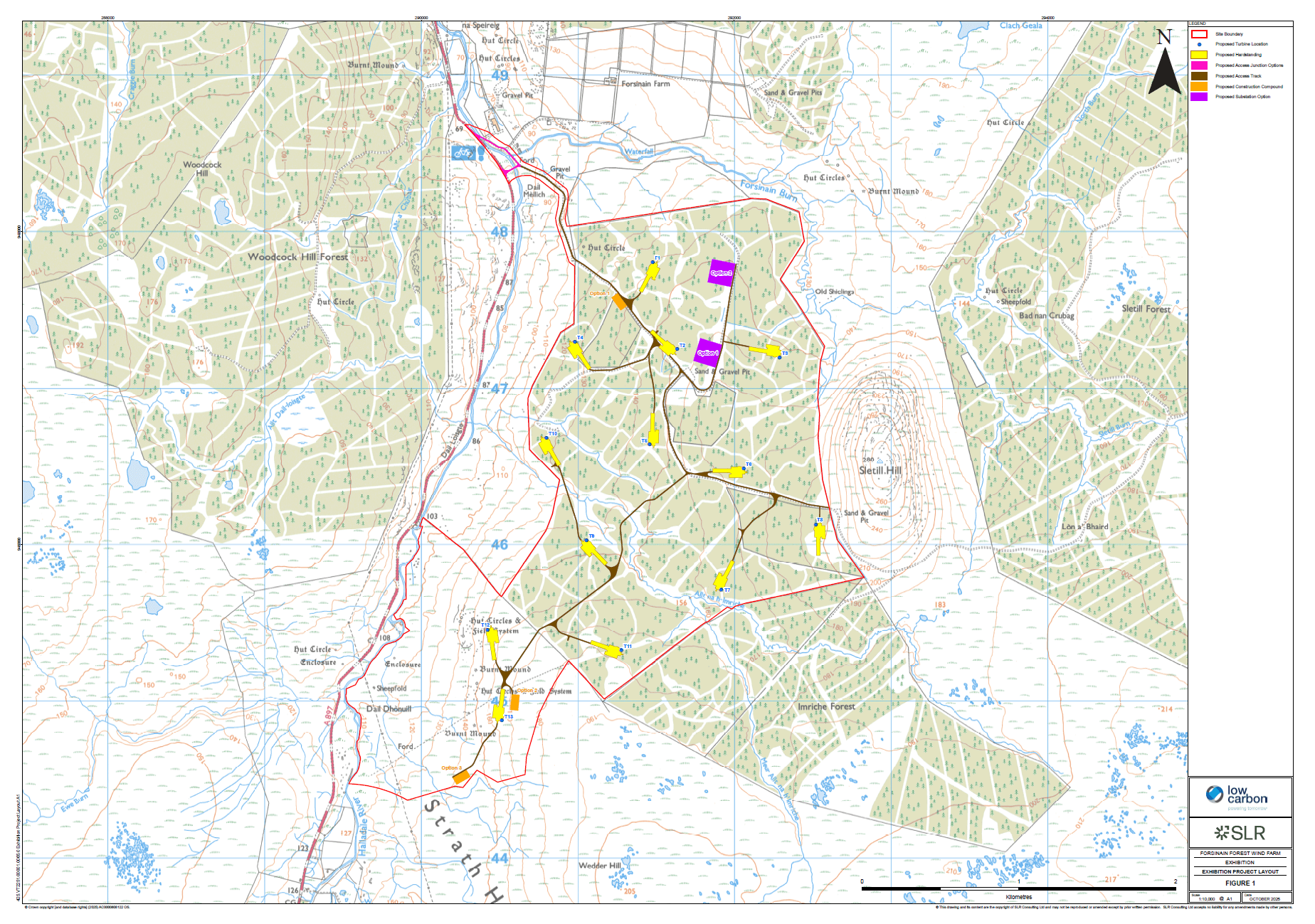
The installed capacity of the Proposed Development would be 86.4 Megawatts (MW), comprising up to 12 stand-alone, three bladed horizontal axis wind turbines. Out of the 12, 10 turbines would have a maximum tip height of 219m and 2 turbines would have a maximum tip height of 206m. The number and location of the turbines and associated infrastructure has been subject to thorough consultation and has now been finalised following a detailed iterative design process.
The Proposed Development also includes extensive habitat management and enhancement measures, including 155 hectares of commercial forest to blanket bog restoration, which are further defined within the Environmental Impact Assessment.
Any predicted environmental effects arising from the Proposed Development have been addressed through embedded mitigation as far as reasonably possible. Where necessary, additional specific mitigation measures have been committed to further reduce adverse effects during the construction, operational and decommissioning phases of the development.
News & Latest Updates
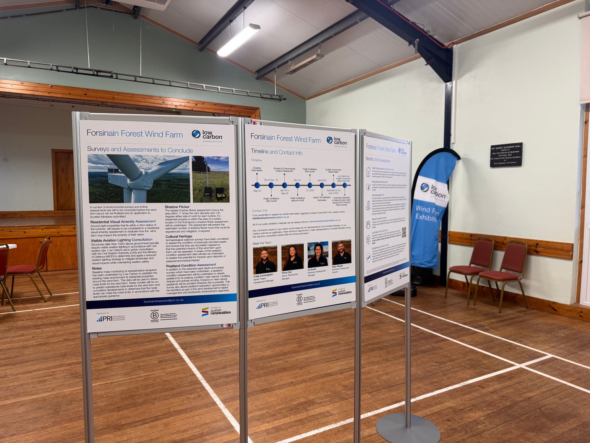
A thank you from the Low Carbon Wind Team
Low Carbon would like to extend our sincere thanks to all those who attended the Forsinain Forest Wind Farm 2nd public exhibition!
It was great to meet many of you across both days, and we enjoyed discussing the proposed development with local residents and community stakeholders. We are now working on collating all your valuable feedback.
If you haven't left us feedback yet, don't worry! There's still time.
You can do this via our Forsinain Forest website, or via post to: FREEPOST: LOW CARBON UK WIND TEAM.
View all NewsBenefits of Low Carbon Development
Across our portfolio of renewable energy projects, we have championed biodiversity as a critical milestone on the journey towards a low-carbon future.
Wind resource is plentiful in Scotland and can be utilised to provide security of supply and add to the renewable energy generation mix.
Biodiversity
It is important that the site is improved for nature and demonstrates a biodiversity enhancement, thus helping to protect and improve new and existing habitats.
Planting
Where appropriate, we will look to enhance the site with additional planting of native species.
Livestock Grazing
We work in partnership with our landowners and tenants to accommodate appropriate livestock grazing throughout construction and operation of our wind farms.
Public Rights of Way
We intend to keep access to public rights of way open throughout construction and operation of the windfarm, subject to health and safety constraints, and will seek to improve access wherever possible.
Community Benefit Fund
Low Carbon is committed to delivering Community Benefit of £5000 per MW installed per annum (index linked) for the operational lifetime of the project in line with the Scottish Government best practice guidance.
Where there is an appetite, Low Carbon will work with communities to explore shared ownership options.
Supply Chain
A variety of suppliers are sourced throughout the development, construction, operation and decommissioning of a wind farm. Where possible, Low Carbon will seek to appoint suppliers offering local employment and/or apprenticeships. Please contact us to note your interest.
FAQs
What are the benefits of onshore wind energy?
Onshore wind energy offers several benefits, including:
Renewable and clean: Wind energy is a renewable source that does not produce greenhouse gas emissions or air pollution during operation.
Energy independence: Onshore wind reduces dependence on fossil fuels and enhances energy security.
Job creation: The wind energy sector creates employment opportunities in manufacturing, construction, operations, and maintenance.
Cost-effective: Once installed, onshore wind farms have relatively low operational costs compared to other forms of energy generation.
Local economic development: Wind farms can contribute to the economic growth of local communities through tax revenues and land lease agreements.
Where are onshore wind farms typically located?
Onshore wind farms are usually situated in areas with consistent and strong wind resources. These can include open rural areas, coastal regions, and hilly or mountainous terrains. The specific location depends on factors such as wind speed, land availability, proximity to electrical infrastructure, and environmental considerations.
What is the lifespan of onshore wind turbines?
The average lifespan of onshore wind turbines is around 25 years, although with proper maintenance, some turbines can operate for longer periods. Over time, older turbines can be replaced or upgraded with more advanced and efficient models to improve energy production.
Are there any environmental concerns for wildlife associated with onshore wind energy?
Wind farms may affect bird migration patterns and local wildlife habitats, although proper site selection and mitigation measures can help minimize these impacts.
Are onshore wind turbines noisy?
Wind turbines can produce low-level noise, although modern designs aim to minimize this impact.
How much electricity can an onshore wind turbine generate?
The electricity generation capacity of an onshore wind turbine varies depending on factors such as the turbine size, wind speed, and duration of operation. A typical modern onshore wind turbine with a capacity of 2 to 3 megawatts (MW) can generate enough electricity to power hundreds of homes annually.
How does onshore wind energy compare to other renewable energy sources?
Onshore wind energy is one of the most established and cost-effective renewable energy sources. It competes favourably with other renewables like solar energy and hydroelectric power in terms of electricity generation capacity, cost, and environmental benefits. The choice of energy source depends on factors such as resource availability, location, and specific energy needs.
Virtual Exhibitions
Second Virtual Exhibition
Second Virtual Exhibition
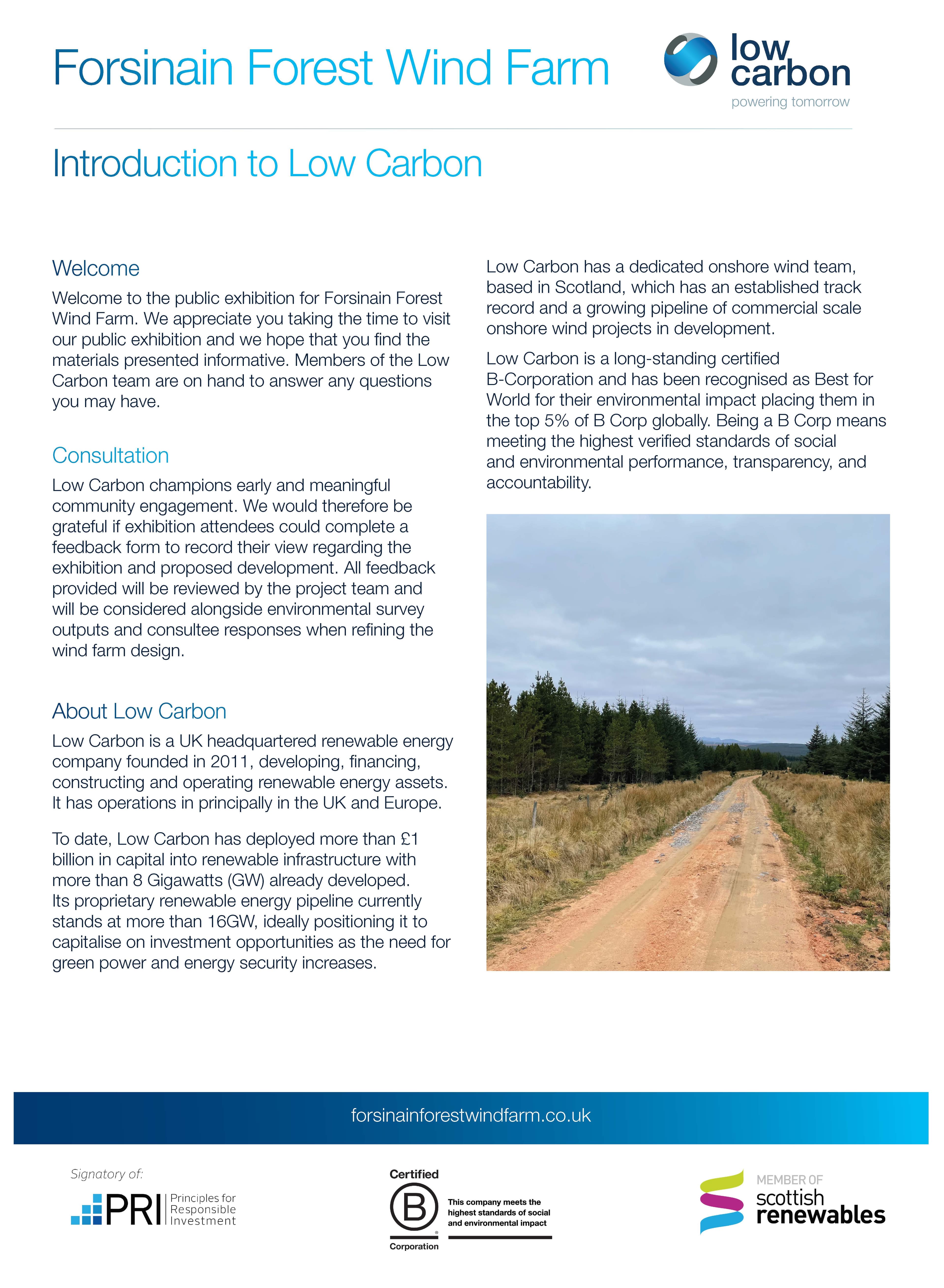
Welcome to the second Public Exhibition for our proposals at Forsinain Forest Wind Farm. The materials presented here are consistent with what we are presenting at our in person events.
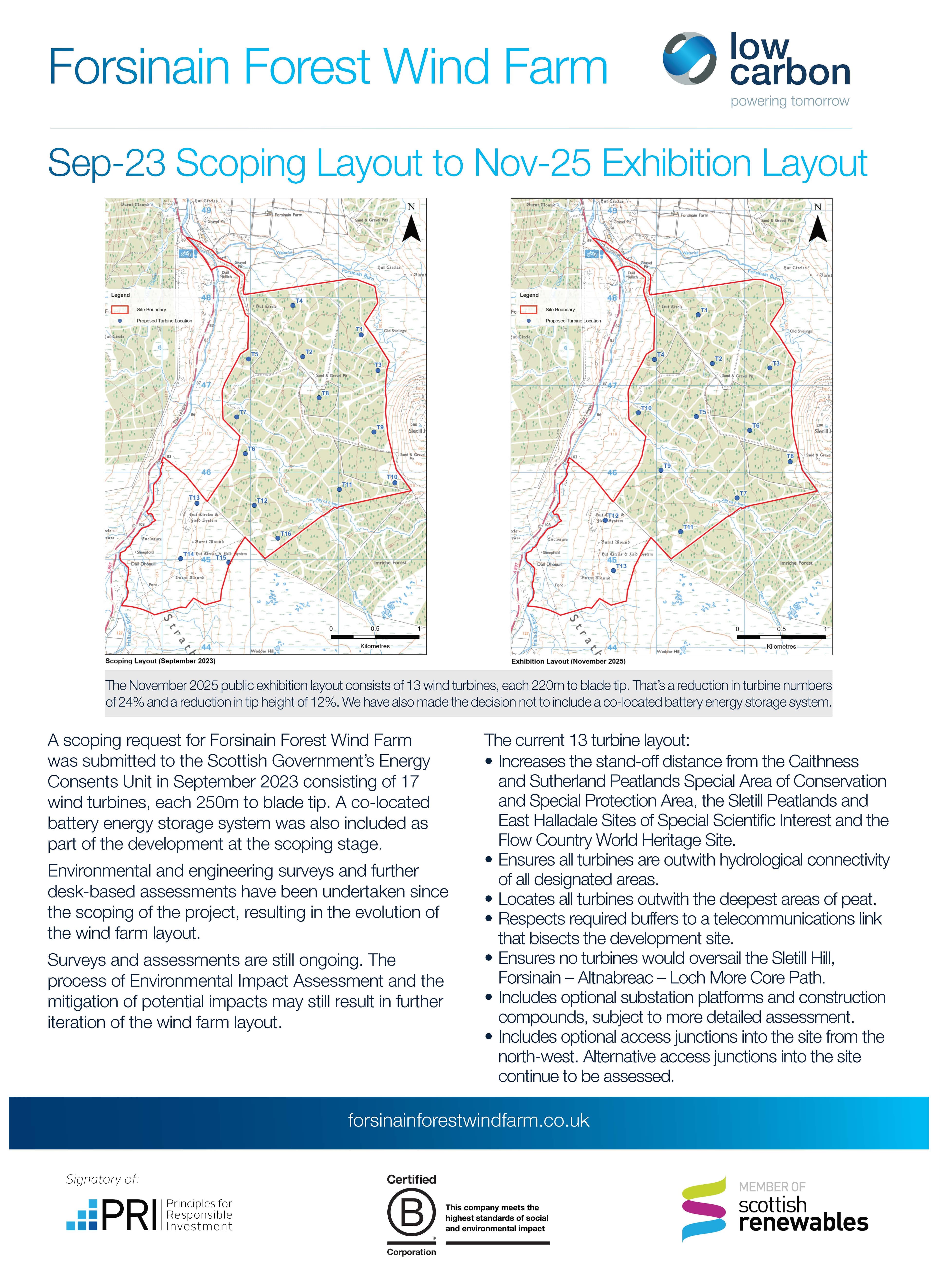
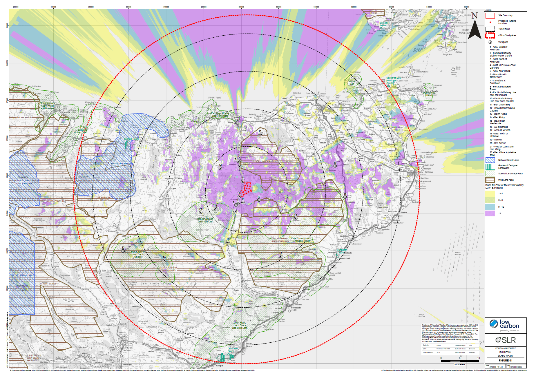
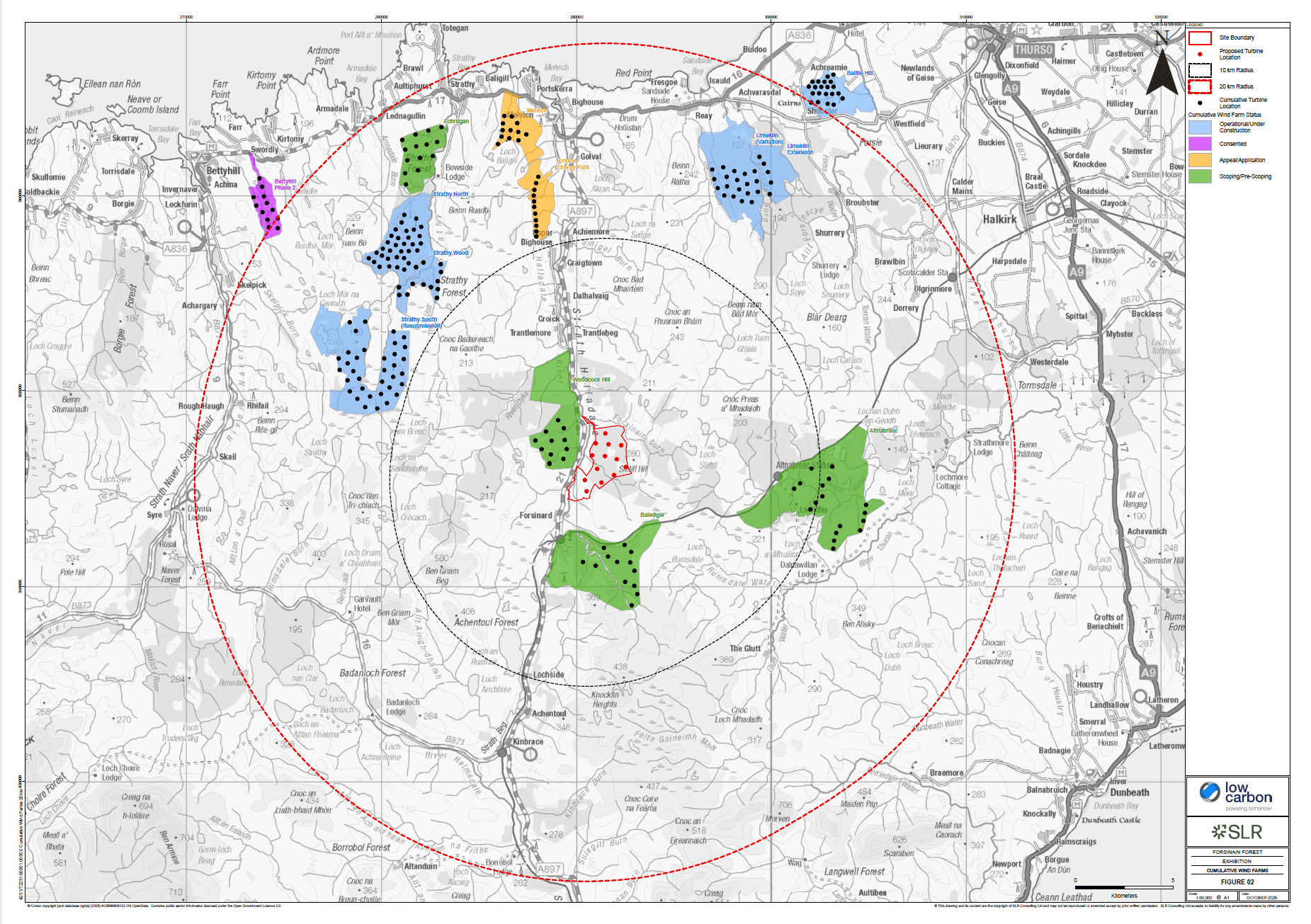
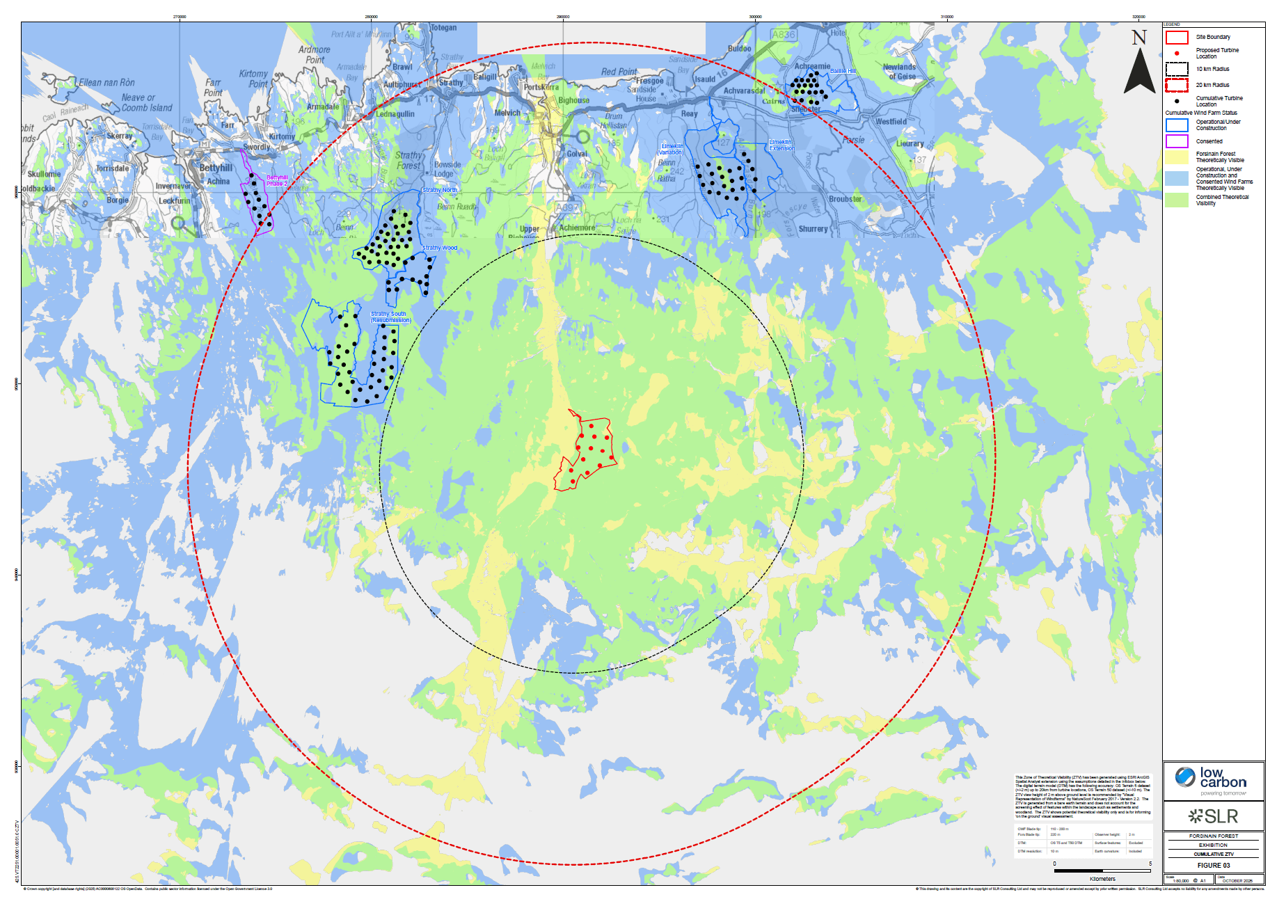
This information provides an overview of how the proposals at Forsinain Forest have been refined since Scoping as further studies, site surveys and stakeholder and community engagement has been undertaken.
Please note: Any comments made to Low Carbon at this stage are not representations to the Scottish Ministers. If Low Carbon submits an application in relation to the Proposed Development, there will be an opportunity to make representations to Scottish Ministers during the statutory consultation period after the formal submission.
Feedback and Contacting Us
We want to ensure the community local to the Proposed Development is fully informed regarding the plans for the project. We encourage feedback and suggestions to help influence the design of the development. Our project website provides a simple and transparent way for the community to provide feedback.